

Investigators have revealed a train which crashed near Stonehaven was travelling at 72.8 miles an hour when it came off the tracks, investigators have revealed.
The Rail Accident Investigation Branch has provided an interim update on its findings from the scene of the incident, more than a week on.
Its statement, released today, said: "On the morning of 12 August, there were thunderstorms with associated heavy rain in southern Aberdeenshire. Weather records indicate that between 05:00 hrs and 09:00 hrs, around 52 mm of rain fell in the Carmont area. This is almost 75% of the total monthly rainfall (70 mm) for Aberdeenshire in an average August.
"The site of the accident was approximately four miles (6.4 km) south-west of Stonehaven and 20 miles (32 km) north of Montrose, on the double track main line which runs between Dundee and Aberdeen.
"The train, which was operated by Abellio (trading as ScotRail), was a High Speed Train set with a leading power car, four Mark 3 passenger coaches and a rear power car.
"It had originally been operating as train reporting number 1T08, the 06:38 hrs service from Aberdeen to Glasgow Queen Street. Train 1T08 had departed on time from Aberdeen and then from Stonehaven, its next scheduled stop.
"After departing from Stonehaven, train 1T08 continued past Carmont on the up (southbound) line until it was stopped by the signaller at Carmont at 06:59 hrs, using a radio message. This was because the signaller had just received a report from the driver of train 2B13, which was on the down (northbound) line, that a landslip was obstructing the up line between Carmont and Laurencekirk.
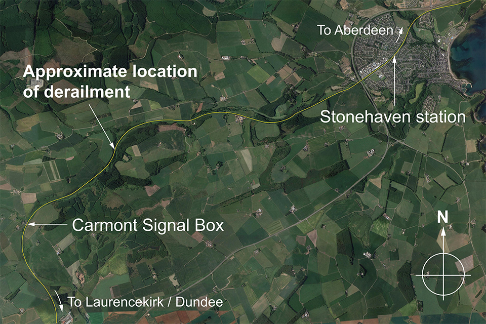
Google Earth image showing locations
"Train 1T08 stood south of Carmont for over two hours. Soon after 09:00 hrs, after the rain stopped, the skies cleared and by 09:30 hrs there was bright sunshine.
"The northbound train (2B13) which had reported the landslip had been held at Stonehaven station because of reports of flooding between Stonehaven and Aberdeen. At 09:10 hrs, after its passengers had alighted, train 2B13 was moved a short distance forward to create space in the platform at Stonehaven.
"It was apparent that train 1T08 could not continue its journey south, and the decision was taken to run it to Stonehaven, to enable onward travel for the passengers.
"At 09:25 hrs train 1T08 was given permission to start moving north, and was routed over a crossover at Carmont onto the down line. The signaller at Carmont cleared the signal for the train to proceed to Stonehaven, and the train continued north, passing over the crossover at 5 mph (8 km/h) at 09:36 hrs.
"Its speed increased, reaching 72.8 mph (117.1 km/h) after it had travelled for approximately 1.4 miles (2.25 km), which is within the maximum permitted speed for HSTs of 75 mph (120 km/h) on this stretch of line.
"At around 09:38 hrs, the train struck a landslip covering the down line and derailed. As the track curved to the right, the train continued in a roughly straight line for around 77 yards (70 metres) until it struck a section of bridge parapet, which was destroyed.
"The leading power car continued most of the way over the bridge and fell from the railway down a wooded embankment, as did the third passenger carriage. The first passenger carriage came to rest on its roof, having rotated to be almost at right angles to the track.
"The second passenger carriage also overturned onto its roof and came to rest on the first carriage. The fourth passenger carriage remained upright and attached to the rear power car; it also came to rest on the first carriage. All wheelsets of the rear power car derailed, but it remained upright.
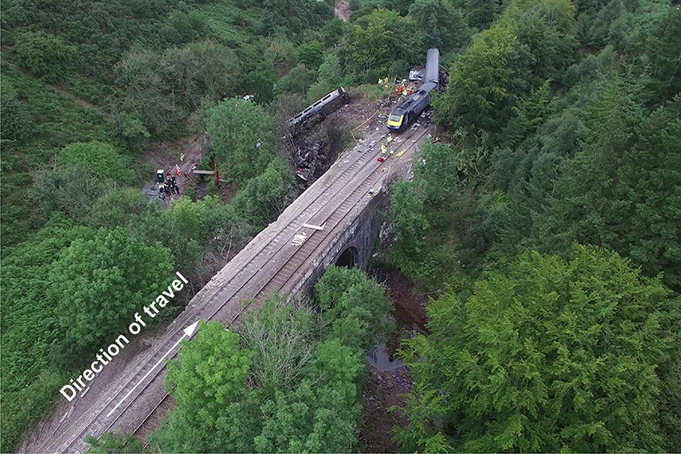
Aerial photograph of derailment site
"In the area where the derailment occurred, on the left-hand side of the railway (in the direction of travel of the train) a slope rises steeply to a field which then slopes gently upwards away from the railway.
"A drain runs northwards along the lower edge of the field until it reaches an access chamber about 50 metres south of the landslip area, from where it runs diagonally down the steep slope, passing through two more access chambers, until it reaches an outfall structure at a track level ditch which takes water northwards towards Carron Water.
"The drain running diagonally consists of a 450 millimetre (18 inch) diameter plastic pipe laid at the bottom of a trench. After the drain was installed, the trench was filled with gravel.
"Water flowing from land above the railway washed some of this gravel onto the railway, together with some larger pieces of rock which had formed part of soil eroded from the sides of the trench."
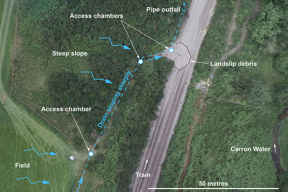
Lineside features in the area of the landslip
The RAIB says it is still collecting evidence and will publish its findings, including any recommendations to improve safety, at the conclusion of the investigation.
 John Swinney announces SNP leadership bid
 Jimmy Thelin appointed new manager of Aberdeen Football Club
 14°C
14°C
 13°C
13°C